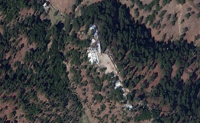
 A high-resolution satellite image of the Jaish-e-Mohammed training camp in Pakistan’s Balakot taken after last month’s Indian air strikes has triggered a controversy as experts argue over the damage caused at the site. While some have said the image shows structures at the terrorist camp still standing, others have pointed to spots that could be possible points that the bombs penetrated before exploding inside.
Incredibly, the image in question came from a private American satellite launched by the Indian Space Research Organisation or ISRO.
Taken days after the February 26 Indian Air Force strike, it was released to news agency Reuters by the San Francisco-based Earth-imaging company Planet Labs Inc.
Most of the over 120 tiny satellites used by Planet Labs were launched from India’s spaceport at Sriharikota, setting a world record of putting in orbit the largest number of satellites – 104 – in a single launch in 2017.
Where Are India’s Own Satellite Images?
The Planet Labs satellites, operating in the low-earth orbit of about 500 km, provide images for the entire globe. They can spot objects less than a meter in length on a daily basis.
However, these images are rivalled by a constellation of 48 satellites operated by India.
But the Indian government has not released any of these images yet.
Dr K Sivan, chairman of ISRO, confirmed to NDTV that all of these satellites “are healthy and helping secure India”.
In general, ISRO designs, fabricates and launches the satellites and after that, “user agencies” – like the armed forces – are handed over the control of the satellites.
All images from India’s high-resolution satellites are directly fed to the National Technical Research Organisation or NTRO, India’s main technical intelligence agency.
As a policy, India does not release images of less than a meter resolution for civilian or public use.
Among the Indian satellites that could have provided high resolution imagery from Balakot are the RADARSATS, Cartosats, Microsat-R, HySIS and even the geo-stationary satellite that looks constantly over India.
India’s best bet, the RISAT-1 that had day and night viewing capability, however, had imploded in orbit in September 2016 before dying in 2017. A replacement is on its way later this year.
But according to sources, RISAT-2, a nimble Israeli spy satellite that India launched in 2009 continues to function and should have been able to provide high resolution images of Balakot.
There is also a large fleet of eight ultra-high resolution imaging satellites called Cartosats which can image objects of less than a meter in length. These eyes-in-the-sky map the world every day and can even lock on to a target to provide high-resolution videos.
As recently as January 24, 2019, ISRO launched Microsat-R, a satellite for “defence research” at a 277 km altitude, which should be able to provide images of the best resolution since it flies at half the altitude of the Planet Labs’ Dove constellation. No other details were released on the 740 kg satellite. This is possibly the lowest orbit on which ISRO has an Indian satellite.
In addition, on November 29, 2018, ISRO launched the HySIS satellite or the Hyper Spectral Imaging Satellite, a tiny 380 kg “hawk’s eye in the sky”. It can take images so sharp that it can distinguish “if structures are made of aluminium or other metals”, the space agency had said.
